A lack of on-the-ground information at the start of a humanitarian crisis is a major obstacle to a quick and effective response. It is critical to know the location and the best way/s to access affected populations. This is particularly difficult in locations where infrastructure and communications networks may be damaged or disrupted.
Project overview
SKAI’s groundbreaking solution represents the future of disaster response and humanitarian assistance. Developed by the World Food Programme (WFP) in collaboration with Google Research, SKAI is revolutionizing the way we tackle world hunger and respond to emergencies.
SKAI uses artificial intelligence (AI) and satellite imagery to enable real-time insights and actionable intelligence for effective decision-making during disaster response. By fusing cutting-edge machine learning algorithms and vast satellite data, SKAI empowers organizations to make data-driven decisions with unprecedented precision and speed. From rapid building damage assessment to situational awareness and resource allocation, SKAI is redefining the way we respond to crises.
The challenge
The solution
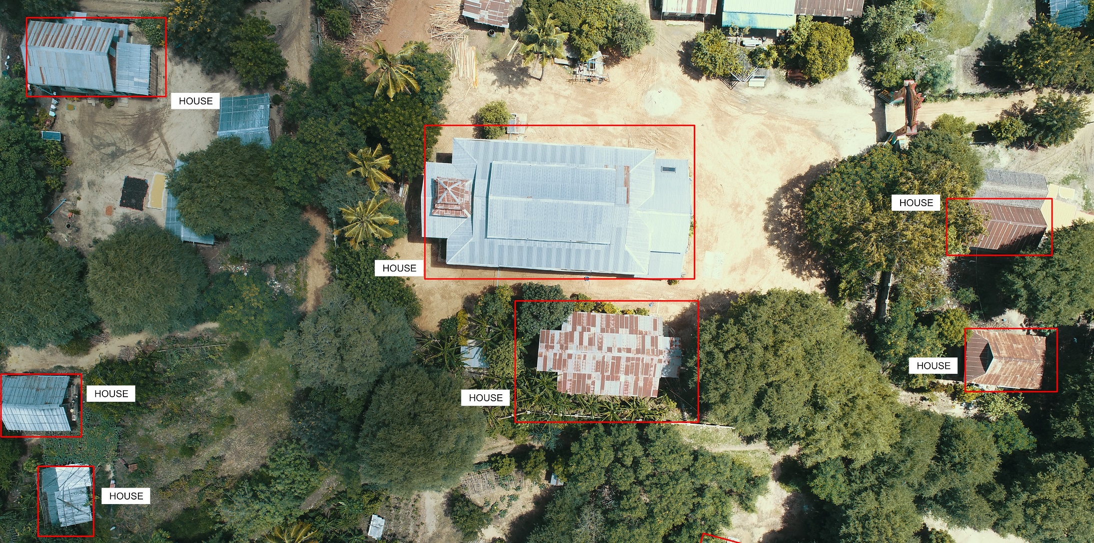
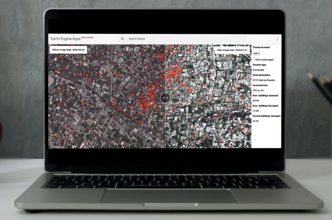
SKAI is an open-sourced tool that uses advanced AI and satellite imagery and to assess building damage on a large scale automatically. It can help to significantly speed up humanitarian assistance to affected households after disasters. Co-developed by the World Food Programme's Innovation Accelerator and Google Research, SKAI leverages AI for satellite imagery analysis, enabling near-real-time damage assessments for buildings in disaster-affected areas.
Unleashing the Power of SKAI: Redefining Disaster Response
SKAI offers unparalleled features and innovations that set it apart as a game-changing platform for disaster response and humanitarian assistance.
Machine Learning-based Damage Assessment
Leveraging state-of-the-art machine learning algorithms, SKAI automatically analyzes satellite images to assess the extent of building damage caused by any natural disasters and conflicts, anywhere at scale – context-agnostic technology. This enables rapid and accurate building damage assessment, facilitating prompt response and aid distribution.
Near Real-time Monitoring and Insights
SKAI provides near real-time monitoring capabilities, allowing tracking and analysis of disaster-affected areas by delivering critical metrics on building damage. Organizations, governments and local authorities, can then combine it with population density, infrastructure mapping, socio-economic vulnerability, and food security, enabling efficient resource allocation and targeted interventions.
Enhanced Situational Awareness
By comprehensively analyzing satellite imagery, SKAI detects changes in buildings’ structures, identifies affected regions, and predicts damage outcomes, equipping organizations with valuable insights for proactive disaster response.
Collaborative and Public Good
SKAI serves as a collaborative solution among stakeholders involved in disaster response and humanitarian aid. This promotes effective collaboration and maximizes the impact of response efforts.
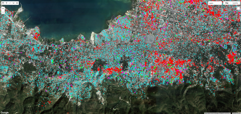
In 2025, SKAI analysed nearly 500,000 buildings after the Myanmar earthquake and more than 300,000 following the Sri Lanka cyclone, while the radar‑based model was tested after an earthquake in Afghanistan. Under SKAI+, the temporary settlement detection model performed strongly at MVP stage and is planned for pilot deployment with WFP country offices in March 2026, marking an important step toward operational integration.
Real-world Impact: Near Real-time Use Cases
Myanmar (2025)
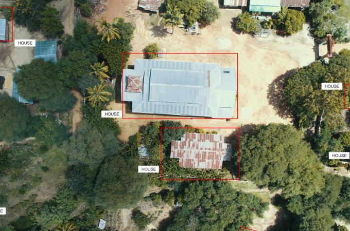
Following the March 2025 earthquake in Myanmar, SKAI enabled a rapid, large‑scale damage assessment to support early response. Using high‑resolution satellite imagery, WFP analysed 460,000 buildings, identifying nearly 4,000 severely damaged or destroyed structures. These insights helped improve situational awareness and prioritize the most affected areas in the critical early phase. In the Pyawbwe region, analysts created paired pre‑ and post‑event imagery to train a supervised machine learning model for building damage classification. This approach allowed teams to quickly prioritize the most severely impacted locations, helping inform early response planning and resource allocation.
Sri Lanka (2025)
After a cyclone struck Sri Lanka in 2025, SKAI supported post‑disaster analysis by rapidly assessing over 300,000 buildings. The model identified 10,476 damaged or destroyed structures (3.45%), helping responders understand the scale and distribution of impact and informing early response planning.
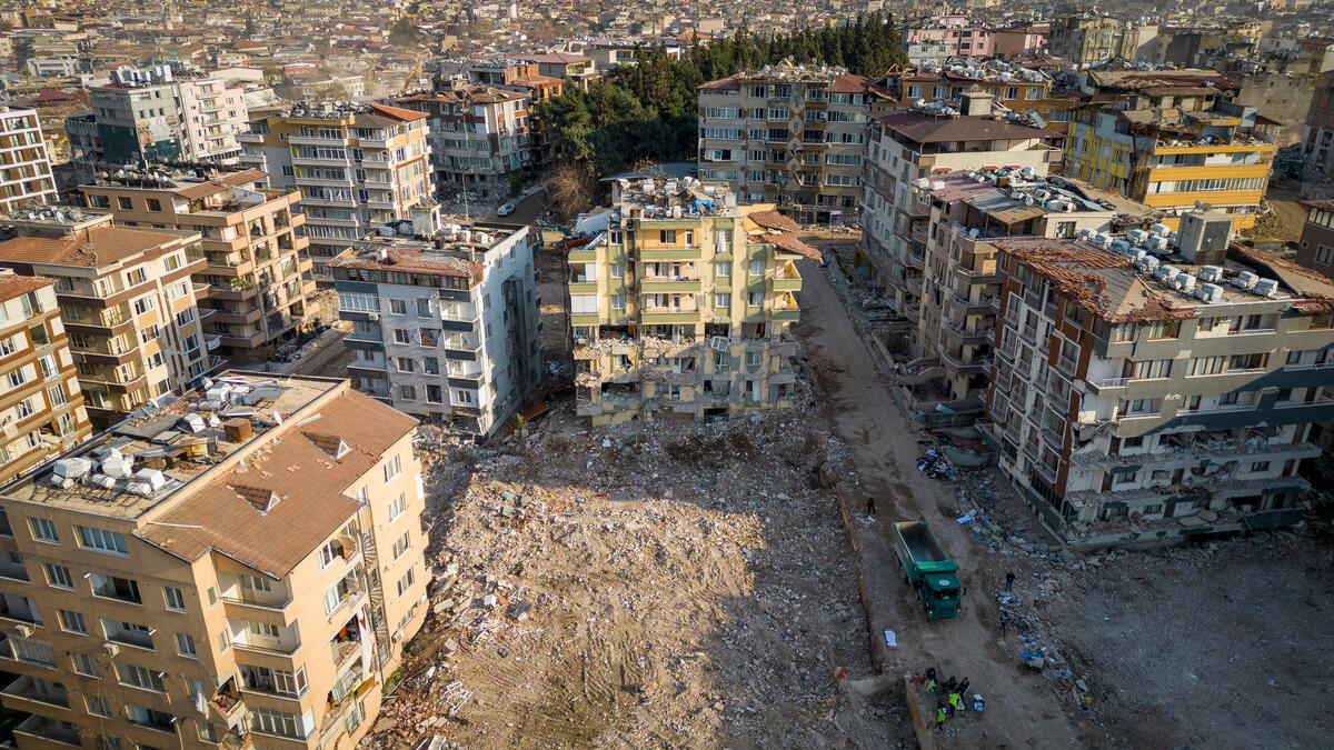
Türkiye Earthquake (2023)
Following the devastating earthquake that struck Türkiye and Syria, SKAI proved to be a valuable tool in disaster response. By providing timely and accurate analysis of the affected areas, SKAI played an important role in assessing damage, and assisting with resource allocation. While the exact measurement of its impacts and outcomes was challenging and not extensively verified, there is evidence to suggest that SKAI’s insights positively contributed to the response effort.
Precise and Accurate Assessment: During a month-long deployment, SKAI’s team of just five individuals demonstrated remarkable capabilities. They assessed approximately 600,000 buildings with an accuracy rate exceeding 81 percent. This assessment helped identify over 28,000 heavily damaged or destroyed structures.
Rapid Coverage of Vast Urban Zones: In less than a week, SKAI's agile technology covered an extensive area of 530 km2 comprising urban zones with an estimated population of 1.3 million people. The analysis of over 265,000 buildings enabled the identification of over 7,000 structures severely damaged or completely destroyed in three major cities: Kahramanmaras, Iskendirun, and Antakya.
Providing Valuable Data: SKAI collected additional satellite imagery and released building damage data covering a portion of the impacted area. This data was estimated to affect approximately 5 million people across southeast Türkiye. While it is important to note that the exact impact of this data-driven approach was difficult to measure and not intensively verified, it aimed to empower decision-makers with the necessary information to plan and execute relief efforts, ensuring that assistance reached those who needed it most.
Hurricane Ian (2022)
In the aftermath of Hurricane Ian, SKAI helped to effectively prioritize aid delivery and assess the impact on affected populations. Through real-time monitoring and damage assessment, SKAI enabled aid organizations, specifically Give Directly, to respond swiftly and effectively, providing critical assistance to those in need.
Enabling Swift and Effective Aid Delivery: With SKAI's real-time monitoring and damage assessment capabilities, Give Directly was able to respond rapidly in the wake of Hurricane Ian, speeding up their disaster responses from several weeks to a few days. In a matter of weeks, over US$2.1 million in cash assistance was delivered in total to 4,761 low-income families residing in heavily impacted neighborhoods of West Florida. This timely intervention provided essential support to those most affected, helping them rebuild their lives and communities.
Unprecedented Speed and Accuracy in Damage Assessment: SKAI demonstrated its remarkable capabilities by scanning 410,000 buildings across 3,000 sqkm within a few days. Through this rapid assessment, SKAI identified 69,000 damaged buildings, achieving an impressive precision and recall rate of approximately 70 percent. These critical insights provided a comprehensive understanding of the impact, allowing Give Directly to open enrollment for cash assistance within less than a week of the hurricane making landfall.
Record-Breaking Assistance Delivery: The combination of SKAI's technology and Give Directly's efficient aid distribution systems enabled the record-breaking delivery of US$ 630,000 in cash assistance to over 900 low-income households residing in heavily impacted areas in a couple of days. This assistance reached those in need weeks earlier than in previous disasters, providing much-needed support for their recovery and ensuring a faster return to normalcy.
Recognized Contributions and Partnerships: The impact of SKAI's technology in the context of Hurricane Ian was widely acknowledged, with both the press and Google's AI@ '22 recognizing its invaluable contributions. Through the partnership between Google and Give Directly, SKAI's capabilities were harnessed to inform relief aid efforts, demonstrating its effectiveness in supporting data-driven decision-making and enabling swift response measures.
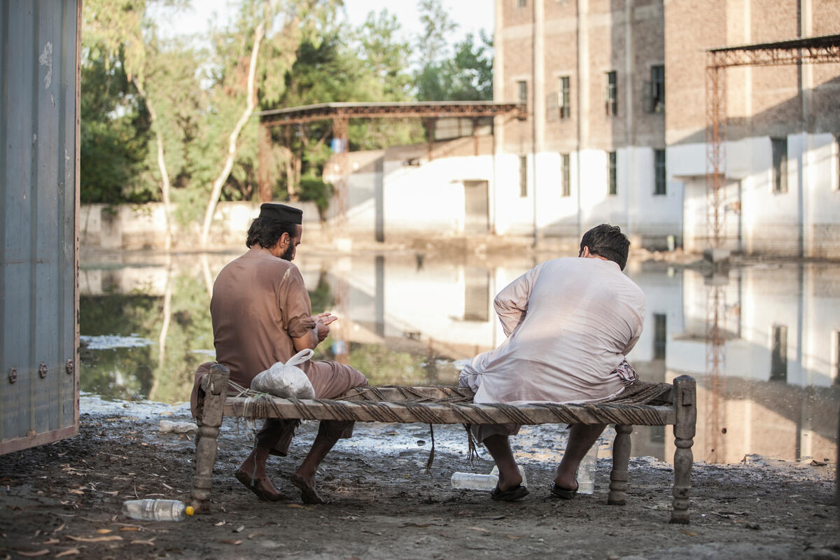
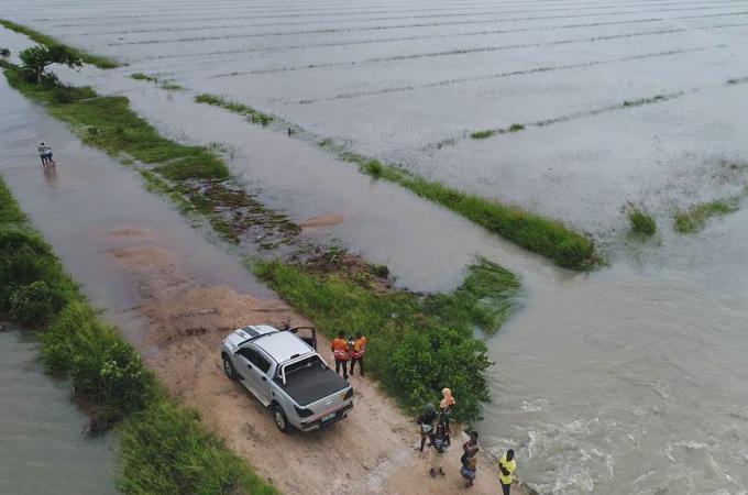
Pakistan Floods (2022)
Amidst the devastating floods in Pakistan, described as "Never seen climate carnage" by UN chief Antonio Guterres, SKAI emerged as a potential game-changing solution in flood response. Its insights facilitated the monitoring of flood-affected regions, identification of the most impacted urban districts and remote villages, and the support of relief assessment efforts conducted by local authorities. The magnitude of SKAI's impact is reflected in the scanning of over 850,000 households across 8000 km2 of land area, directly benefiting approximately 2.5 million people.
Transforming Flood Response with Timely Insights: In the face of an unprecedented disaster, SKAI's technology provided situational awareness tools that supported flood response efforts. By accurately monitoring the affected areas, SKAI enabled a proactive approach to relief operations.
Enhancing Relief Assessment and Transparency: The data generated by SKAI's analysis was shared with the Pakistan authorities, serving as a valuable resource to counter-verify the damage observed during ground surveys. This collaborative approach ensured a comprehensive and transparent process, mitigating risks associated with incomplete assessments. The recognition received from the Khyber Pakhtunkhwa (KPK) provincial government is a testament to the efficacy and reliability of SKAI's technology in addressing these critical challenges.
Empowering Provincial Disaster Management Authorities: With the sheer scale of the impacted area, manual door-to-door surveys conducted by the provincial government faced significant challenges in terms of time and resource requirements. SKAI's technology emerged as a game-changer by empowering provincial disaster management authorities in the KPK province. Through the identification of over 60,000 damaged buildings, SKAI achieved an impressive precision rate of 80-85 percent and a recall rate of 65-70 percent.
“Thank you and your research team for using machine learning technology and satellite imagery to generate building damage assessments in the most-impacted district of Dera Ismail Khan. The reach and precision metrics of your findings are commendable.”
Muhammad Mughess Sanaullah, Director, Performance management and reforms unit, Government of Pakistan
Durban Region Floods (2022)
After the catastrophic Durban flash floods in April 2022, SKAI provided insights on the affected areas and infrastructure damage and played a role in facilitating post-disaster assessment with the South African WFP team.
Assessment of Flood Impact: After the South African floods occurred, the WFP Country Office and the provincial government sought support in assessing the extent of the damage. SKAI analyzed nine areas within the region, covering over 250,000 residential buildings and infrastructures. With an exceptional precision rate of 88 percent and a recall rate of 73 percent, SKAI successfully identified over 7,768 buildings that were damaged, providing valuable information for recovery efforts.
Empowering Decision-Making and Collaboration: The per-building and per-infrastructure assessment maps generated by SKAI were shared with the WFP South African Country team. These maps became tools for communication and validation, enabling the identification of impacted wards and quantifying the severity of the impact. SKAI's data empowered local authorities to better understand and classify the effects of infrastructural damage, fostering effective collaboration and informed decision-making.
SKAI’s the limit?
As well as being used directly by humanitarian organizations, there is immense potential for SKAI to be integrated within the systems of local and national authorities to enhance and reinforce their suite emergency response tools. WFP is open to collaborating with local and national authorities to adapt SKAI models to the needs and challenges of specific regions. For example, by leveraging national satellite capacities and data sources, SKAI assessments can be tailored to the local context, increasing accuracy and relevance. Through knowledge exchange and capacity building, the SKAI project team can also provide training to local staff, empowering them to utilize SKAI effectively and independently.
SKAI will also be the core technology of the upcoming Disha platform, which aims to leverage AI and data innovation for sustainable development and humanitarian action. Led by UN Global Pulse, Disha brings together a coalition of partners including: Google.org; the Patrick J. McGovern Foundation; the Jain Family Institute; McKinsey & Company; the World Food Programme (WFP); the United Nations Development Programme (UNDP) and; the United Nations Satellite Centre (UNOSAT). By integrating SKAI’s powerful capabilities into Disha, its reach and impact will be expanded, driving greater efficiency, and fostering collaboration among diverse stakeholders across disaster response, and beyond.
Invest in the Future of Disaster Response
SKAI's implementation in recent real-world scenarios has reinforced its position as a transformative tool in emergency response and recovery. By harnessing the power of AI, SKAI exemplifies the potential of technology to make a tangible and life-saving impact in the most challenging situations, transforming disaster response into a proactive and efficient endeavor.
If you are an investor or an organization passionate about leveraging AI for disaster response and humanitarian aid, join us in advancing the capabilities of SKAI and making a profound impact on global humanitarian efforts. Contact us today to explore partnership opportunities, contribute to ongoing projects, or support the development and deployment of SKAI in disaster-prone regions for any type of damage assessment (building, infrastructures, crop field and more).
Discover SKAI on GitHub
For a deeper understanding of SKAI's technical details, methodologies, and code, explore our GitHub repository. Learn more by engaging with the SKAI community, contributing to ongoing projects, and helping to shape the future of AI-driven disaster response.
Meet the team

Amine Baha
Artificial Intelligence and Machine Learning Strategy and Portfolio Project Manager

Jorge Fernandes
Head of Innovative Finance and Frontiers Innovation
Rizwan Sadiq
AI Technical Solution Consultant
Last updated:
28/04/2026
Related News


14 November 2017